Florida — Forecasters are closely monitoring a developing weather system in the northeastern Gulf of Mexico that could organize into a tropical depression or even Tropical Storm Bertha early next week, while increasing the risk of heavy rainfall across Florida and parts of the southeastern United States.
Although the system is not expected to become a powerful tropical cyclone at this time, meteorologists say residents should keep a close eye on the forecast as conditions could change quickly during the Atlantic hurricane season.
Gulf Low Could Develop This Weekend
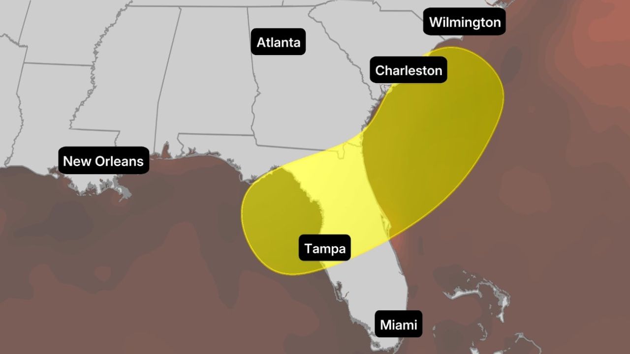
Weather forecasters expect an area of low pressure to form in the northeastern Gulf near Florida by Saturday or Sunday.
If thunderstorms become more organized around the center of circulation, the disturbance could develop into a tropical depression or Tropical Storm Bertha as early as this weekend or early next week.
The system will have access to very warm Gulf waters, with sea surface temperatures reaching the upper 80s, providing enough energy to support thunderstorm development.
However, forecasters note that the system may not remain over water long enough to strengthen significantly.
Current forecast models suggest the disturbance could move quickly across northern Florida before either emerging off the Southeast coast or continuing inland.
Another, less likely scenario would see the low pressure system stall over the Gulf before drifting west or northwest next week, though forecasters currently consider that possibility relatively low.
Heavy Rain May Be the Biggest Threat
Even if the system never becomes a named tropical storm, weather experts warn that locally heavy rainfall is expected from Florida into the Carolinas through the weekend and into early next week.
The greatest concern currently appears to be across northern and central Florida, where rainfall totals could exceed the area’s normal summertime afternoon thunderstorms.
Meteorologists say the developing weather pattern is associated with a weakening frontal boundary stretching across the Southeast, which will provide additional moisture and increase rainfall potential.
While much of the region has been experiencing drought conditions and could benefit from widespread rain, intense downpours may overwhelm drainage systems, especially in cities and low-lying areas.
Flash Flooding Could Develop in Some Areas
Forecasters say localized flash flooding remains possible where repeated heavy showers develop.
Urban neighborhoods, poor drainage areas and locations that receive multiple rounds of rain in a short period could see water accumulate quickly.
Residents are encouraged to monitor local forecasts, especially if they live in flood-prone communities. Emergency officials also remind drivers to avoid traveling through flooded roadways, as water depth can be difficult to judge.
Atlantic Hurricane Season Continues to Heat Up
In addition to the Gulf disturbance, forecasters are also tracking a tropical wave moving westward from the coast of Africa.
The National Hurricane Center currently gives that system a low chance of tropical development, although gradual organization remains possible as it moves across the eastern Atlantic.
Meteorologists note that tropical waves emerging from Africa often struggle during June and July because of dry Saharan dust and strong wind shear, conditions that can prevent storms from strengthening.
As hurricane season continues, forecasters encourage residents along the Gulf Coast and Atlantic coastline to review emergency plans and remain prepared for rapidly changing weather conditions.
What are your thoughts on this developing weather system? Are you preparing for hurricane season where you live? Share your plans and stay weather-aware by following the latest forecast updates.