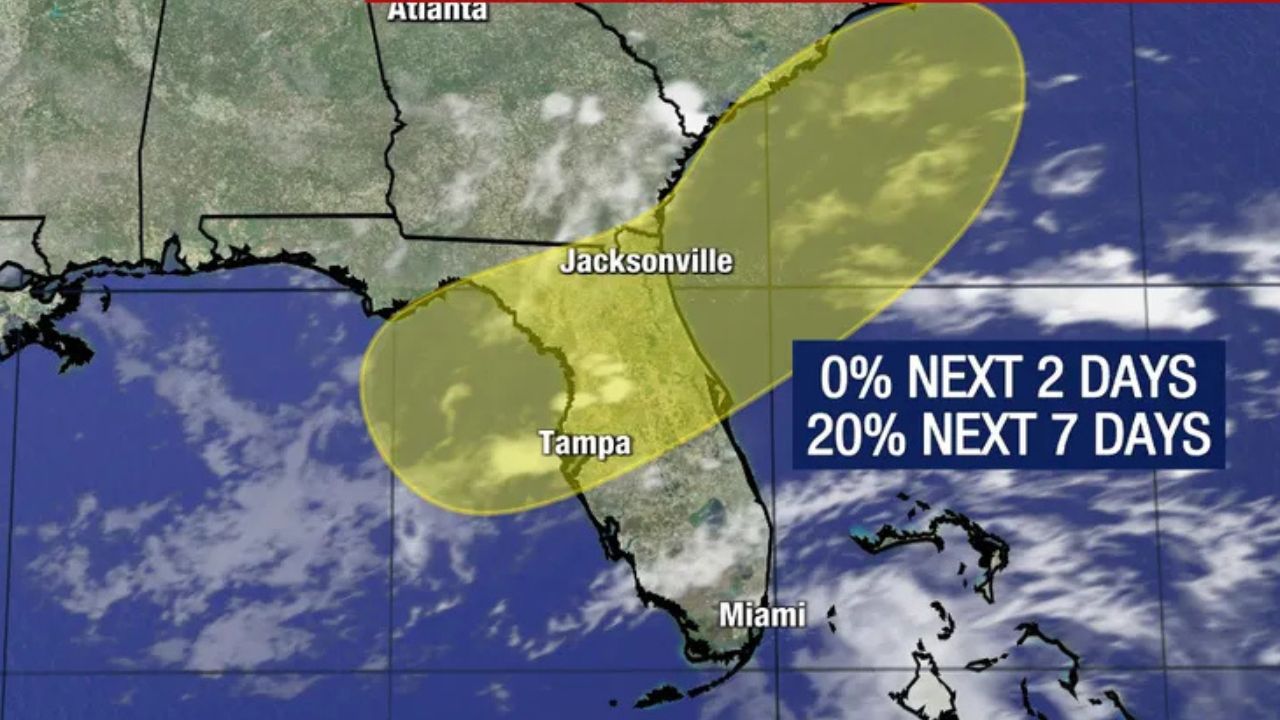
Tampa, Florida — Forecasters are closely monitoring a developing weather system in the northeastern Gulf of Mexico that could bring widespread rain and localized flooding to Florida this weekend, even if it never officially becomes a tropical storm.
According to the National Hurricane Center (NHC), the disturbance currently has a 20% chance of tropical development during the next seven days, while meteorologists continue tracking its potential path across the Gulf and into the southeastern United States.
Although confidence in tropical development remains low, residents across Florida are being urged to stay informed as the system is expected to increase rainfall across much of the state.
Gulf Disturbance Could Bring Heavy Rain Across Florida
Forecast models continue to indicate that an area of low pressure may develop over the northeastern Gulf off Florida’s west coast during the weekend.
Meteorologists expect the system to move northeast across Florida before exiting into the Atlantic Ocean near the Carolinas.
Even if the disturbance remains weak, it is expected to transport deep tropical moisture into Florida, increasing the risk of periods of heavy rain, localized flooding and thunderstorms.
Forecasters say the greatest impacts are likely to be from rainfall rather than damaging winds.
Warm Gulf Waters Could Support Development
One factor working in the system’s favor is the exceptionally warm Gulf waters.
Sea surface temperatures across the northeastern Gulf are currently in the upper 80s to near 90 degrees, providing plenty of energy that could help a tropical system organize.
However, meteorologists caution that warm water alone is not enough to produce a named storm.
The disturbance will also have to overcome several atmospheric obstacles before significant strengthening can occur.
Several Factors Could Prevent a Tropical Storm
Forecasters say there is still considerable uncertainty regarding how organized the system will become.
Potential challenges include wind shear, dry air and interactions with land, all of which can disrupt the development of tropical systems.
Computer forecast models continue to show different scenarios, making it too early to determine whether the disturbance will remain a weak low-pressure area or strengthen into a tropical depression or tropical storm.
To become an officially named tropical storm, the system would need a well-defined circulation and maximum sustained winds of at least 39 mph.
If that happens, the next name on the Atlantic storm list would be Bertha.
Rain Could Benefit Drought-Stricken Parts of Florida
While heavy rain could create localized flooding concerns in some communities, meteorologists note that the additional moisture may also provide much-needed relief for areas experiencing drought.
The Tampa area remains approximately 7.5 inches below its average annual rainfall, and drought conditions continue across large portions of Florida.
A slow-moving tropical system or weak area of low pressure could help reduce that rainfall deficit if widespread precipitation develops over the state during the weekend.
Meanwhile, forecasters are also monitoring a separate tropical wave in the eastern Atlantic near the Cabo Verde Islands. The National Hurricane Center currently gives that system only a 10% chance of development, with conditions expected to become less favorable later this weekend.
Residents across Florida are encouraged to continue monitoring official forecasts as the weekend approaches, since the track and strength of the Gulf disturbance could still change.
Do you think this Gulf system will become Tropical Storm Bertha, or will it remain a rainmaker? Share your thoughts and let us know how the weather is looking in your area in the comments below.