Pittsburgh, Pennsylvania — After a pleasant start to the week, residents across the Pittsburgh area should prepare for a significant change in the weather on Tuesday as forecasters warn that strong to severe thunderstorms could impact much of western Pennsylvania.
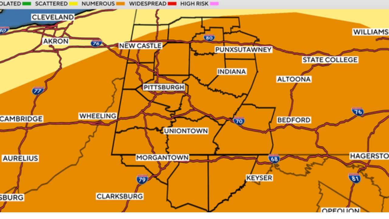
Meteorologists have designated Tuesday as a First Alert Weather Day, with the region placed under an Enhanced Risk (Level 3 out of 5) for severe thunderstorms. The higher risk level means there is increased confidence that numerous storms could become severe as a cold front moves through the area.
Officials are urging residents to stay weather-aware and have multiple ways to receive warnings throughout the day.
Pleasant Weather Ends as Cold Front Approaches
Monday is expected to remain comfortable, with mostly sunny skies, low humidity and afternoon highs in the low 80s, offering near-normal temperatures before conditions change.
The quiet weather will give way to a much more active pattern on Tuesday as a powerful cold front approaches western Pennsylvania.
As the front moves across the region, thunderstorms are expected to develop and strengthen during the afternoon hours.
Damaging Winds, Flash Flooding and Tornadoes Possible
Forecasters say the primary threats with Tuesday’s storms include:
- Damaging wind gusts
- Flash flooding from heavy rainfall
- Small hail
- The possibility of isolated tornadoes
Storms are expected to begin developing north of Pittsburgh after noon before tracking southward through the city and surrounding communities during the afternoon and evening.
The greatest threat is expected before 5 p.m., although some storms could continue into the evening as the cold front exits the region.
Residents are encouraged to monitor weather updates closely, especially if they have outdoor plans or an afternoon commute.
Cooler, Drier Weather Returns Midweek
Once the cold front moves out, conditions are expected to improve significantly.
A few lingering showers may remain possible on Wednesday, but much of the remainder of the week is forecast to feature below-normal temperatures, lower humidity and more comfortable conditions.
The cooler pattern is expected to provide a welcome break after several weeks of warmer-than-average weather.
July Has Been Warmer and Wetter Than Normal
So far this month, the Pittsburgh area has experienced temperatures running more than 5 degrees above average, along with approximately 1.30 inches more rainfall than normal.
Tuesday’s storm system is expected to add to July’s active weather pattern before cooler air settles across the region for the second half of the week.
Residents should stay informed of the latest forecasts, especially as conditions can change rapidly during severe weather events. Having multiple ways to receive watches and warnings can help ensure you have enough time to seek shelter if dangerous storms develop.
Do you think western Pennsylvania has experienced more severe storms than usual this summer? Let us know how the weather is affecting your area in the comments below.