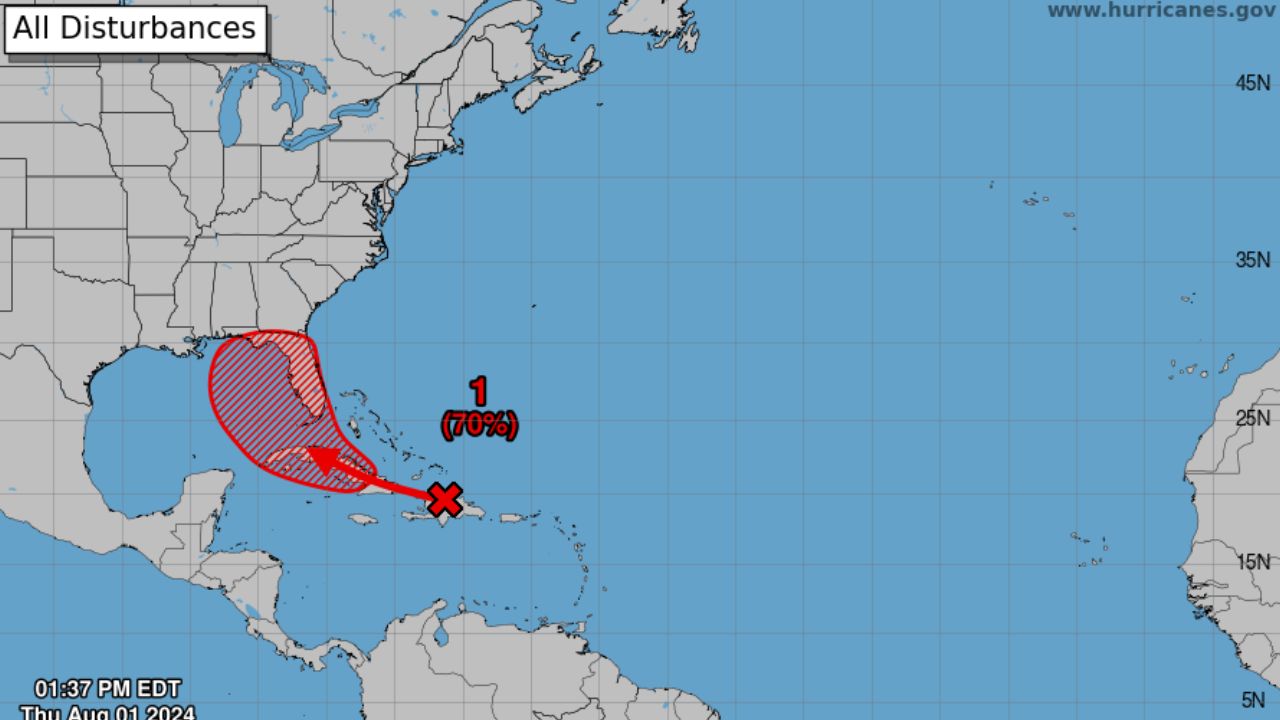
Houston, Texas — Forecasters are closely monitoring a tropical disturbance in the eastern Gulf of Mexico that could develop into the Atlantic’s next named storm this week. While the system may bring unsettled weather to parts of the northern Gulf Coast, meteorologists say Houston and much of Southeast Texas are expected to avoid any significant impacts.
According to the National Hurricane Center, the disturbance now has a 50% chance of tropical development over the next 48 to 72 hours, increasing from 40% earlier in the weekend.
If the system strengthens into a tropical storm, it would be named Bertha, becoming the second named storm of the 2026 Atlantic hurricane season after Tropical Storm Arthur.
Why Houston Is Expected to Stay Out of Harm’s Way
Meteorologists say a strong ridge of high pressure positioned off the Texas coast is expected to prevent the developing system from moving west toward Southeast Texas.
The weather pattern should steer the disturbance toward the eastern Gulf instead, keeping the most active weather well away from Houston.
While forecasters will continue monitoring the system, current projections indicate Houston is not expected to experience direct tropical impacts.
Residents may notice slightly higher rain chances by Wednesday or Thursday if some of the storm’s outer moisture reaches the region, but widespread heavy rain or damaging winds are not currently anticipated.
Florida Panhandle and Northern Gulf Coast Could See Rough Weather
Forecast models currently suggest the disturbance could move toward the Florida Panhandle before tracking closer to coastal Louisiana early next week.
If the system develops, communities from Destin and Pensacola to New Orleans could experience periods of unsettled weather, including:
- Heavy rainfall
- Gusty winds
- Rough surf
- Dangerous rip currents along Gulf Coast beaches
Officials encourage residents and travelers with plans along the northern Gulf Coast to continue monitoring forecasts as the system evolves.
Hurricane Season Is Becoming More Active
The Atlantic hurricane season officially runs from June 1 through November 30, with activity typically increasing during the second half of July before reaching its peak between late August and September.
Meteorologists note that this time of year often sees tropical waves moving across the Atlantic and Caribbean before entering the Gulf of Mexico, making regular monitoring increasingly important.
Although many July systems remain weak, forecasters say conditions can change quickly during the heart of hurricane season.
Houston Also Bracing for Dangerous Heat
Even without significant tropical weather, hot temperatures will be the biggest concern across Southeast Texas this week.
Forecasts call for highs climbing into the upper 90s, with Houston potentially reaching its first 100-degree day of 2026 by Thursday.
Heat index values are expected to rise well above 100 degrees, increasing the risk of heat-related illnesses. Forecasters say heat advisories may be issued later this week if the extreme temperatures continue.
Residents are encouraged to stay hydrated, limit strenuous outdoor activities during the hottest part of the day, and keep an eye on the latest tropical forecasts as the Gulf system develops.
Do you think this tropical system will strengthen into Tropical Storm Bertha? If you’re along the Gulf Coast, how are you preparing for hurricane season? Share your thoughts in the comments below.