TAMPA, Fla. — The Atlantic is entering a period when tropical activity typically begins to increase, but unfavorable atmospheric conditions are keeping tropical waves from gaining strength as the region approaches the peak of the hurricane season.
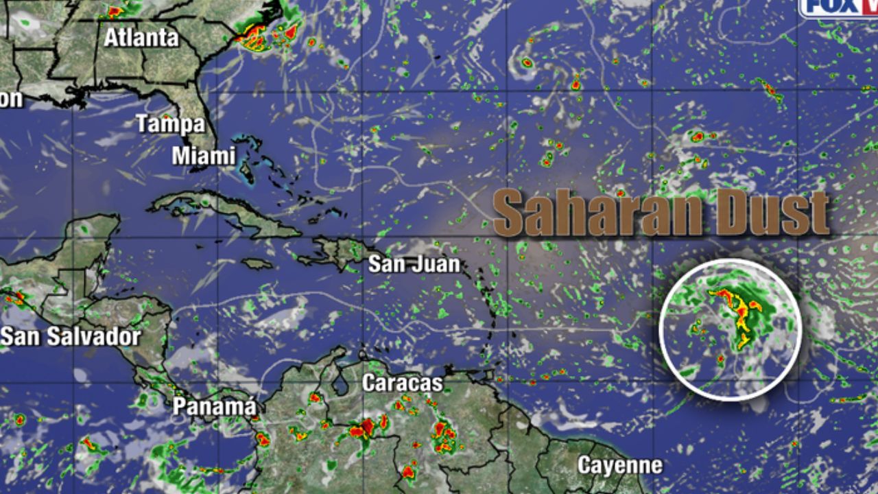
Several tropical waves are moving westward toward the Caribbean, but the environment ahead of them remains hostile to development. Strong wind shear and Saharan dust are disrupting the organization of these systems, reducing the likelihood that they will quickly strengthen into tropical storms.
Tropical Waves Struggle Against Unfavorable Conditions
Tropical waves are common features across the Atlantic during hurricane season and can sometimes become the starting point for tropical storms or hurricanes. However, not every wave encounters an environment capable of supporting development.
At the moment, high wind shear is one of the biggest obstacles facing tropical systems. Strong winds at different levels of the atmosphere can disrupt the circulation of developing disturbances, making it difficult for thunderstorms to remain organized around a central area.
Saharan dust is adding another layer of unfavorable conditions. Dry, dusty air moving westward from Africa can suppress thunderstorm activity and make the atmosphere less supportive of tropical development.
As a result, tropical waves heading toward the islands are currently facing significant environmental headwinds.
Atlantic Hurricane Season Nears Its September Peak
The timing is notable because the Atlantic is approaching the climatological peak of hurricane season on September 10.
The period around early to mid-September is typically one of the most active portions of the Atlantic hurricane season. Tropical waves become increasingly important during this time, and forecasters generally watch the Atlantic closely for signs that disturbances could become organized.
More tropical waves are expected to emerge in the coming weeks as the season progresses. However, the current atmospheric setup is expected to keep conditions relatively quiet in the immediate future.
That means residents across the Caribbean and other areas that regularly monitor tropical weather may have a short window of calmer conditions before activity potentially becomes more significant.
Storm Alert for Philadelphia: Torrential Rain, Flash Flooding and Severe Winds Expected Thursday
What Remains Uncertain for September
While conditions are currently unfavorable, the atmosphere can change quickly during hurricane season.
One of the biggest questions is whether Saharan dust and strong wind shear will decrease enough to allow future tropical waves to organize as September approaches. A change in either factor could make the Atlantic environment more supportive of development.
At this point, there is no certainty about when conditions will become more favorable. Forecasters will continue watching new waves emerging over the Atlantic and tracking how their surrounding environment changes as they move westward.
Quiet Weather Expected Over the Next Several Days
For now, the tropical Atlantic is expected to remain relatively quiet for the next five to seven days.
That does not mean the remainder of the hurricane season will stay quiet. Instead, the current forecast reflects the immediate atmospheric conditions that are limiting development.
With the September peak approaching, forecasters will continue monitoring tropical waves, wind shear, Saharan dust and other environmental factors that could influence storm formation.
For residents and communities in hurricane-prone areas, the quieter period provides another opportunity to review emergency plans and stay prepared before the traditionally more active part of the season arrives.
Do you think the Atlantic will become more active as September approaches? Share your thoughts in the comments below.